

.gif)

.gif)
Oxford University Manages Estates With Indoor Mapping
The University of Oxford has upgraded its estates management processes with a new indoor mapping system. Offering easy access to property and interiors data...
Read Full Article.png)
The Leading News & Information Service For The Facilities, Workplace & Built Environment Community

Esri UK and Tetra Tech have joined forces to provide indoor digital twins to make buildings smarter.
Esri UK has announced a new partnership with Tetra Tech to offer customers an end-to-end solution for indoor mapping, designed to capitalise on an increasing demand for indoor mapping for facilities management at large offices, facilities, campuses, or hospitals.
Indoor mapping provides users with interactive digital twin floorplans, helping to improve operational efficiency by giving staff a clear picture of where things are and how to reach them, for improved building performance and asset management. Esri UK’s current indoor mapping customers include The University of Oxford and large energy providers, while Tetra Tech works with major energy, government and defence customers.
“We are already seeing an increased demand for indoor mapping this year as organisations return to work and can benefit from the digitalisation of their floorplans, which leads to better facilities management going forward.”
–Jeff Van Etten
Head of GIS UK, Tetra Tech
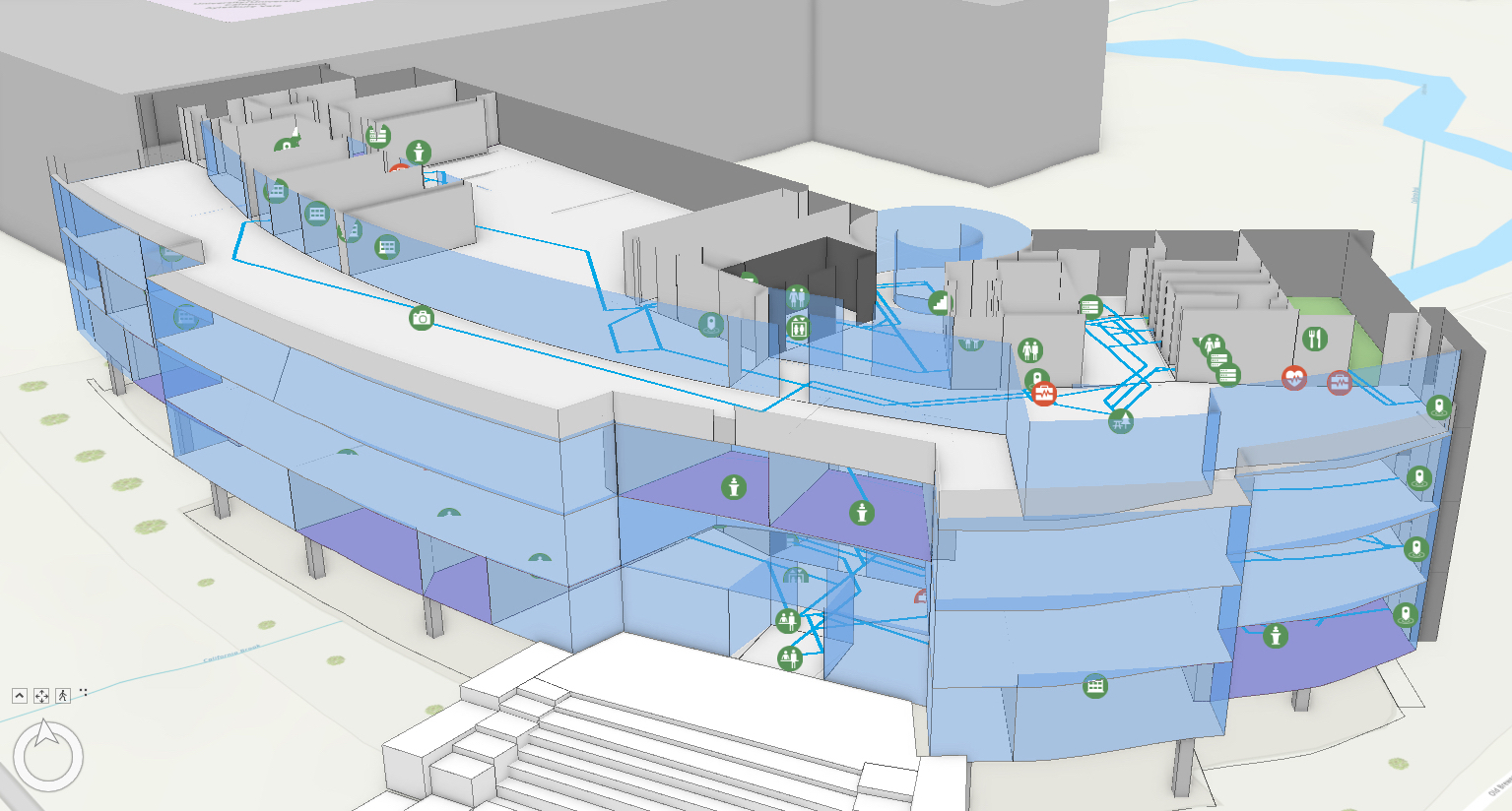
Picture: a screenshot of Esri UK's 3D indoor mapping software
Offering the complete workflow, global consulting and engineering services company Tetra Tech will provide the necessary 3D terrestrial laser scanning, data analytics and CAD to GIS expertise, while Esri UK will offer its GIS system with numerous indoor mapping capabilities, including interactive floorplans, indoor positioning for wayfinding plus real-time people and asset tracking.
The firms will work on joint projects within the facilities management, AEC (architecture, engineering and construction), transport, defence and healthcare industries. One area of focus will be helping organisations return to work as COVID-19 restrictions lift.
“As the demand for indoor mapping starts to become more widespread, the new partnership is designed to make the process of creating indoor maps more efficient and streamlined for customers,” explained Craig Evenden, Head of AEC & BIM at Esri UK.
“Esri UK and Tetra Tech offer very complementary skillsets, ideal for helping organisations progress their digital transformation and achieve a better understanding of their buildings and assets. We are experiencing demand from the higher education, energy, defence and healthcare sectors, as organisations look to make their buildings smarter and improve how they manage them.”
Services offered by Tetra Tech include all types of fixed and handheld lidar scanning, from millimetre precision to larger-scale centimetre resolution, depending on the application. For customers who have existing CAD or BIM data, Tetra Tech offers data preparation and cleansing services. Esri UK will be delivering its various software applications for indoor mapping, including ArcGIS Pro, ArcGIS Online and ArcGIS Indoors to accommodate any type or size of project. Indoor mapping can integrate and complement existing facilities management software by giving users a geographical visualisation of their estates.
“Our 'Leading with Science' approach is valued by our clients and augmented by a suite of proprietary technologies and analytical tools we call the Tetra Tech Delta. We are using Tetra Tech Delta solutions to transform static CAD or BIM data into an accessible, interactive and analytical environment. We make sure the correct data, at the optimum resolution, is ready for processing by indoor mapping software,” explained Jeff Van Etten, Head of GIS in the UK at Tetra Tech.
“We are already seeing an increased demand for indoor mapping this year as organisations return to work and can benefit from the digitalisation of their floorplans, which leads to better facilities management going forward.”
Esri UK and Tetra Tech are holding a joint webinar on Tuesday 30 March 2021 at 3.00-4.00pm, to explore how indoor mapping can help understand site layouts, assets and navigation. The University of Oxford will be discussing how recent innovations in indoor mapping will be helping it improve the efficiency of asset management, budgeting and building planning, across its complex estate of more than 300 buildings.
Picture: a photograph of a hand holding a smartphone, using an indoor mapping screen. Staff or visitors can use indoor mapping on smartphones to find places or assets
Article written by Ella Tansley | Published 16 March 2021
The University of Oxford has upgraded its estates management processes with a new indoor mapping system. Offering easy access to property and interiors data...
Read Full ArticleTwinview and Nordic BIM Group have announced a strategic partnership to implement digital twins across the property sector in Sweden, Finland and Norway. This will...
Read Full ArticleA new fund has been launched to invest €200 million in start-up companies developing sustainable tech to target the carbon footprint of cities. The venture...
Read Full ArticleBentley Systems and Microsoft are to collaborate to accelerate smart city urban planning and smart construction. This alliance will combine Microsoft’s Azure IoT...
Read Full ArticleDigital twins have been described as being able to provide “previously unthinkable” levels of operational control, asset performance management and...
Read Full ArticleWith extreme weather a recurring operational risk, facilities management teams must retrofit existing buildings to keep them comfortable, compliant and...
Read Full ArticleFM provider Service Works Global has released a new white paper that details the seven steps for creating a smart building. The paper dispels the assumption...
Read Full ArticleMRI Software has completed its $93.4 million stock acquisition of PropTech Group. The deal has secured approval from the Australian Competition and Consumer...
Read Full ArticlePlanon has acquired a majority share in Ubigreen, a PropTech company based in Toulouse, France. Ubigreen specialises in energy and sustainability management...
Read Full ArticleFelipe Ávila da Costa, Co-Founder & CEO at Infraspeak, shares his reflections on the past year and his predictions for human-centric maintenance in...
Read Full Article
.png)

.png)